Jannes Stolte
Seniorforsker
(+47) 974 04 696
jannes.stolte@nibio.no
Sted
Ås - Bygg O43
Besøksadresse
Oluf Thesens vei 43, 1433 Ås (Varelevering: Elizabeth Stephansens vei 21)
Biografi
Min langsiktige erfaring er på nedbørfelts-hydrologi, med vekt på jordfysiske prosesser. Jeg har utført studier på jorderosjon i Nederland, Kina og Norge, og har utviklet og grundig testet en fysisk basert hydrologisk og jorderosjonsmodell. Prosesser som flom, måkeerosjon og sediment- og næringstap er kjernen i arbeidet mitt. Jeg har analysert og definert; (i) måleteknikk for modellparametere; (ii) feltovervåking for kvantifisering; (iii) modellanalyse; (iv) definere tiltak for å redusere erosjon, flomrisiko og jordforringelse; (v) valg av mulige tiltak; og (vi) kvantifisering av utvalgte arealbruksstrategier.
Mitt vitenskapelige mål er å opprettholde jord av god kvalitet og redusere flom- og erosjonsrisiko, med fokus på jordfunksjoner og økosystemtjenester. Det er et overbevisende behov for å utvikle et grundig risikobasert rammeverk for å vurdere jordhelse. Jeg tror at ved å implementere en arealbruksstrategi som bruker landskapet til å fange og fordrøye vann, vil avrenning avta, noe som resulterer i en nedgang i flom- og erosjonsrisiko. Hvis jordbrukspraksis samtidig fokuserer på økning av organisk materiale og infiltrasjonskapasitet, vil jordkvaliteten øke så vel som jords evnen til å utføre sine funksjoner. Jord av god kvalitet er nødvendig for mat, fiber og drivstoff for en voksende befolkning, noe som gjør jorda til en delt ressurs som krever å bli ivare tatt.
Sammendrag
Studien undersøkte hvordan ulike dreneringssystemer (torpedo-, slisse- og tradisjonelle grøfter) påvirker hydrologi, nitrogentap, lystgassutslipp og avling av korn på marin leire. Bakgrunnen er økende nedbørintensitet som gjør god drenering nødvendig for å sikre avlinger. Forsøket ble gjennomført fra 2023 til 2025 på Grimsrud gård, Østfold der vannstrømning, jordfuktighet, nitrat i drensvann og klimagassutslipp ble målt. Tekniske problemer førte imidlertid til databrudd i flere sesonger. Hydrologiske data viste store variasjoner mellom både systemer og år. Torpedogrøftene hadde ofte noe høyere avrenning og langsommere tørkehastighet, trolig på grunn av høyere jordfuktighet og mulig jordpakking. Nitratmålinger viste ingen entydige forskjeller mellom systemene, og stor romlig variasjon mellom grøfter gjorde det vanskelig å beregne representative N‑tap. Sensorene viste karakteristiske nitratpulser under nedbør, men episodisk avrenning skapte usikkerhet. Lystgassmålingene viste gjennomgående høyere N₂O‑utslipp i torpedosystemet, særlig under våte forhold tidlig i sesongen. Dette indikerer økt denitrifikasjon i perioder med begrenset dreneringsytelse. Avlingsregistreringer viste ingen systematiske forskjeller mellom dreneringsmetodene. Samlet viser resultatene at forskjeller mellom systemene er vanskelige å dokumentere sikkert på grunn av stor naturlig variasjon og tekniske utfordringer. Videre overvåkning med forbedret måleoppsett anbefales for å kunne vurdere langtidseffekter på hydrologi og nitrogentap.
Sammendrag
Abstract Background and Aims Efficient phosphorus (P) and management is essential for sustainable arable systems. Cover crops (CCs) are promising, but their performance is uncertain in high-latitudes. This three-year study evaluated CCs’ effects on P dynamics in a P-rich soil undersown in barley in Mid-Norway (63.9°N)—one of the northernmost trials of its kind. Methods A randomized complete block design included three CC treatments: ryegrass (CC1), a ryegrass–clover mix (CC2), and a four species mix including grass, legumes and herbs (CC3), and controls without CC (with/without NPK fertilizer). Soil and plant analyses included total and available P, total N, potentially mineralizable N (PMN), pH, permanganate-oxidizable carbon, root biomass, plant P concentrations, and microbial abundance via qPCR. Statistical analysis was based on Linear Mixed Models (LMMs). Results Cover crops successfully established (average biomass: 1525 kg ha⁻ 1 ), accumulated ~ 7 kg P ha⁻ 1 , and did not reduce barley yields. LMMs showed significant effects of CC treatment on root biomass, total P, and bacteria. Pairwise comparisons also revealed that fungal abundances in CC1 and CC3 were significantly higher than in the unfertilized control. Pairwise regression revealed that soil total P was strongly predicted by root biomass (β = 1.37, P < 0.001). Available P was negatively controlled by microbial pools (Bacteria: β = -9.22, P < 0.001) and residue quality (C:P ratio: β = -0.36, P < 0.001). Conclusions CCs can be used at 63°N without yield penalty. The primary P mechanism is mass-driven sequestration (root biomass) into the stable total P pool. However, P availability is temporally constrained by residue quality and microbial competition. Graphical Abstract
Sammendrag
This policy brief outlines the urgency and opportunity for advancing soil health and agroecology in the Nordic region. It highlights the essential ecosystem services provided by healthy soils, the risks of continued degradation, and regionally adapted actions to support sustainable food systems. Key recommendations include developing Nordic-specific monitoring frameworks, incentivizing agroecological and adjacent practices, and fostering regional collaboration and innovation.
Divisjon for miljø og naturressurser
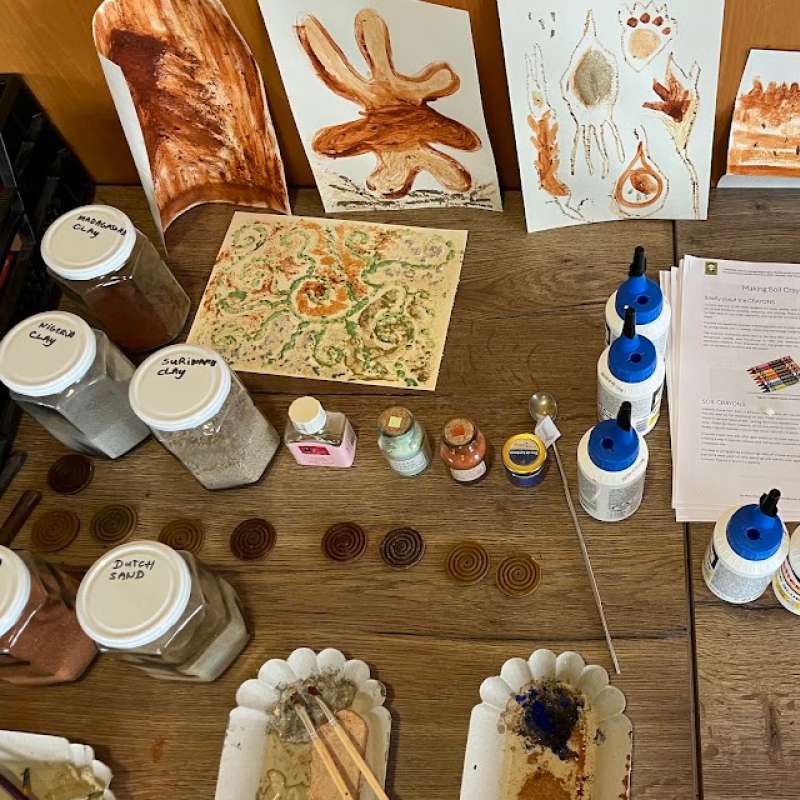
CURIOSOIL
Igjennom CURIOSOIL skal jordundervisningen styrkes, i og utenfor klasserommet for alle aldersgrupper. Målet er å vekke interessen for jord og fremme jordkunnskap i Europa.

Divisjon for miljø og naturressurser
CURIOSOIL
Through CURIOSOIL, soil education will be strengthened, both in classrooms and at other learning arenas, for all age groups. The aim is to enhance soil literacy in Europe.
Divisjon for miljø og naturressurser
EUROSION
European Soil Erosion Monitoring and Modelling Network for Sustainable Agricultural Land Management