Eva Skarbøvik
Senior Research Scientist
Biography
Education
Experience and competence:
- Water quality monitoring according to the EU Water Framework Directive
- Environmental measures in catchments
- Integrated water resources management
- Erosion and transport processes in rivers
- Effects of climate change on water courses
- Environmental effects of hydropower development (hydrology, water chemistry, sediment loads).
Abstract
No abstract has been registered
Authors
Eva Skarbøvik Sofie Gyritia Madsen van't Veen Emma E. Lannergård Hannah Tabea Wenng Marc Stutter Magdalena Bieroza Kevin Atcheson Philip Jordan Jens Fölster Per-Erik Mellander Brian Kronvang Hannu Marttila Øyvind Kaste Ahti Lepistö Maria KämäriAbstract
Climate change in combination with land use alterations may lead to significant changes in soil erosion and sediment fluxes in streams. Optical turbidity sensors can monitor with high frequency and can be used as a proxy for suspended sediment concentration (SSC) provided there is an acceptable calibration curve for turbidity measured by sensors and SSC from water samples. This study used such calibration data from 31 streams in 11 different research projects or monitoring programmes in six Northern European countries. The aim was to find patterns in the turbidity-SSC correlations based on stream characteristics such as mean and maximum turbidity and SSC, catchment area, land use, hydrology, soil type, topography, and the number and representativeness of the data that are used for the calibration. There were large variations, but the best correlations between turbidity and SSC were found in streams with a mean and maximum SSC of >30–200 mg/l, and a mean and maximum turbidity above 60–200 NTU/FNU, respectively. Streams draining agricultural areas with fine-grained soils had better correlations than forested streams draining more coarse-grained soils. However, the study also revealed considerable differences in methodological approaches, including analytical methods to determine SSC, water sampling strategies, quality control procedures, and the use of sensors based on different measuring principles. Relatively few national monitoring programmes in the six countries involved in the study included optical turbidity sensors, which may partly explain this lack of methodological harmonisation. Given the risk of future changes in soil erosion and sediment fluxes, increased harmonisation is highly recommended, so that turbidity data from optical sensors can be better evaluated and intercalibrated across streams in comparable geographical regions.
Authors
Anne Lyche Solheim Anne Tolvanen Eva Skarbøvik Bjørn Kløve Dennis Collentine Brian Kronvang Gitte Blicher-Mathiesen Fatemeh Hashemi Artti Juutinen Seppo Hellsten Eija Pouta Jan VermaatAbstract
No abstract has been registered
Authors
Jan Vermaat Eva Skarbøvik Brian Kronvang Artti Juutinen Seppo Hellsten Katarina Kyllmar Anne Lyche Solheim Bjørn KløveAbstract
No abstract has been registered
Abstract
Soil loss by erosion threatens food security and reduces the environmental quality of water bodies. Prolonged and extreme rainfalls are recognized as main drivers of soil erosion, and climate change predictions for large parts of the world foresee such increases in precipitation. Erosion rates are additionally affected by land use, which may change as a result of the shift from a fossil fuel-based economy to an economy relying on using renewable biomass, a “Bioeconomy”. In this study we aimed at investigating, through modelling, i) if future changes in land use, due to a bioeconomy, would increase the risk for soil loss and enhance suspended sediment yields in streams and ii) if these changes, when combined with climate change effects, would further aggravate suspended sediment conditions in a catchment. We used hydrological and bias adjusted climate models to compare the effect of seven land use pathways on discharge and sediment transport relative to a baseline scenario under present and future climate conditions. The study was carried out based on data from a small headwater stream, representative for cereal production areas of S-E Norway. By modelling our scenarios with the PERSiST and INCA-P models, we found that land use change had a greater influence on both future water discharge and sediment losses than a future climate. Changes from climate showed strongest differences on a seasonal basis. Out of the modelled land use pathways, a sustainable pathway manifested the least occurrence of extreme flood and sediment loss events under future climate; whereas a pathway geared towards self-sufficiency indicated the highest occurrence of such extreme events. Our findings show that careful attention must be placed on the land use and soil management in the region. To maintain freshwater quality, it will be increasingly important to implement environmental mitigation measures.
Authors
Rolf Larsson Antti Belinskij Bjørn Kløve Diana Meilutyte-Lukauskiene Elve Lode Eva Skarbøvik Vytautas AkstinasAbstract
The European Union (EU) Water Framework Directive is of paramount importance for water management. According to the legal text, coordination with other directives like the Floods Directive is imperative and motivated by potential synergy effects. In this paper, the degree to which such coordination is achieved is evaluated for five Nordic and Baltic countries. The evaluation is based on legal documents, management plans, as well as on organizational structure in the five countries. The results show that the coordination between the Water Framework Directive and the Floods Directive (or flood management for Norway's case), have been successful for Estonia and Lithuania, whereas Norway, Finland, and especially Sweden need to improve more.
Abstract
The species composition of benthic algae changes as water phosphorus concentrations increase, and these changes can be used for ecological status assessment according to the Water Framework Directive. Natural background phosphorus concentrations in rivers and streams that are unaffected by anthropogenic impacts are usually low. Running waters draining catchments with deposits of marine clay, however, may have enhanced phosphorus concentrations, because the clay is naturally rich in apatite. Almost all clay rich areas have been cultivated for centuries, however, and fertilization has increased the soil phosphorus levels. It has, therefore, been difficult to disentangle natural from anthropogenically enhanced phosphorus in streams draining clay rich areas. We compared water phosphorus concentrations, and the Periphyton Index of Trophic Status PIT, between clay and non-clay, impacted and unimpacted rivers in Norway. We found that water phosphorus concentrations and the PIT index were higher in unimpacted clay rivers than in unimpacted non-clay rivers, indicating that natural phosphorus concentrations in clay rivers are indeed enhanced compared to rivers without deposits of marine clay. In addition, phosphate-P contributed 18–23% to total phosphorus in unimpacted clay rivers, but 33–37% in unimpacted and impacted non-clay rivers and clay rivers affected by agriculture. This indicates that the total phosphorus in unimpacted clay rivers is less bioavailable than in non-clay rivers and in impacted clay rivers. Water total phosphorus concentrations in unimpacted clay rivers significantly increased with catchment clay cover. Based on these findings, we derived new status class boundaries for the PIT index in clay rivers. Clay rivers are suggested to be assessed in only two status classes, i.e., “good or better” or “moderate or worse”, respectively. The good/moderate status class boundary for the PIT index was shown to increase with increasing catchment clay cover.
Abstract
No abstract has been registered
Abstract
No abstract has been registered
Abstract
No abstract has been registered
Abstract
Increased nutrient and soil losses from agricultural areas into water bodies constitute a global problem. Phosphorus is one of the main nutrients causing eutrophication in surface waters. In arable land, phosphorus losses are closely linked to sediment losses. Therefore, a better understanding of the sediment-runoff processes in agricultural areas is a key to reduce the eutrophication impacts and to implement mitigation measures. The objectives of this study were to identify dominant sediment runoff processes in cultivated grain-dominated catchments in a cold climate. We assessed continuous high-resolution turbidity data, temporal and spatial catchment properties and agricultural management data to describe and get a better understanding of the cause-relationship of sediment transfer in two small agricultural dominated catchments in southern Norway. The concentration-discharge pattern, index of connectivity and agricultural activities were considered with the wider aim to establish a link between field and catchment scale. The results showed that the dominant concentration-discharge pattern was a clockwise concentration-discharge (c-q) hysteresis in both catchments indicating that areas close to or in the stream gave the highest contribution to turbidity. The main driver for turbidity was discharge, though soil water storage capacity, rain intensity and former discharge events also played a role. Intensity of soil tillage and index of connectivity (likelihood of water and particles to be transported to the stream) impacted the c-q hysteresis index. Little vegetation cover and high intensity of soil tillage led to a high hysteresis index, which indicates a quick increase in turbidity following increased discharge. Other links between agricultural management and in stream data were difficult to interpret. The findings of this study provide information about discharge, field operations and vegetational status as drivers for turbidity and about the spatial distribution of sediment sources in two agricultural catchments in a cold climate. The understanding of sediment runoff processes is important, when implementing management actions to combat agricultural emissions to water most efficiently.
Abstract
In the future, the world is expected to rely increasingly on renewable biomass resources for food, fodder, fibre and fuel. The sustainability of this transition to bioeconomy for our water systems depends to a large extent on how we manage our land resources. Changes in land use together with climate change will affect water quantity and quality, which again will have implications for the ecosystem services provided by water resources. These are the main topics of this Ambio special issue on ‘‘Environmental effects of a green bio-economy’’. This paper offers a summary of the eleven papers included in this issue and, at the same time, outlines an approach to quantify and mitigate the impacts of bioeconomy on water resources and their ecosystem services, with indications of useful tools and knowledge needs.
Abstract
Land use and climate change can impact water quality in agricultural catchments. The objectives were to assess long-term monitoring data to quantify changes to the thermal growing season length, investigate farmer adaptations to this and examine these and other factors in relation to total nitrogen and nitrate water concentrations. Data (1991–2017) from seven small Norwegian agricultural catchments were analysed using Mann–Kendall Trend Tests, Pearson correlation and a linear mixed model. The growing season length increased significantly in four of seven catchments. In catchments with cereal production, the increased growing season length corresponded to a reduction in nitrogen concentrations, but there was no such relationship in grassland catchments. In one cereal catchment, a significant correlation was found between the start of sowing and start of the thermal growing season. Understanding the role of the growing season and other factors can provide additional insight into processes and land use choices taking place in agricultural catchments.
Authors
Eva Skarbøvik Jukka Aroviita Jens Fölster Anne Lyche Solheim Katarina Kyllmar Katri Rankinen Brian KronvangAbstract
Reference conditions of water bodies are defined as the natural or minimal anthropogenically disturbed state. We compared the methods for determining total phosphorus and total nitrogen concentrations in rivers in Finland, Norway and Sweden as well as the established reference conditions and evaluated the possibility for transfer and harmonisation of methods. We found that both methods and values differed, especially for lowland rivers with a high proportion of agriculture in the catchment. Since Denmark has not yet set reference conditions for rivers, two of the Nordic methods were tested for Danish conditions. We conclude that some of the established methods are promising but that further development is required. We moreover argue that harmonisation of reference conditions is needed to obtain common benchmarks for assessing the impacts of current and future land use changes on water quality.
Abstract
Denne rapporten er en litteratursammenstilling over tap av suspendert stoff, fosfor og nitrogen fra arealer med hhv. jordbruk og skog/utmark. I tillegg er det gjort en vurdering av tilsvarende tap i perioden der nydyrking gjennomføres. I de norske studiene som er gjennomgått er gjennomsnittlige tap av nitrogen 17 ganger høyere fra jordbruk enn fra skog. Tilsvarende er fosfortap 56 ganger høyere og tap av suspendert stoff 106 ganger høyere fra jordbruk enn fra skog.
Abstract
No abstract has been registered
Abstract
Phosphorus retention and bank erosion was investigated in two types of buffer zones in cereal fields in Norway: zones used for grass production and zones with natural vegetation. Farmers’ views on the two types of buffer zones were collected through questionnaires and indepth interviews. Our results indicate that the grassed buffer zones had higher levels of plant-available phosphorus and lower infiltration rates than the natural ones. Bank erosion was higher in zones with grass production than those with trees. Interviews with farmers revealed diverging opinions on the zones. Most farmers were sceptical to natural vegetation with trees, whereas farmers who had already planted trees in the riparian zones were generally satisfied. Buffer zones can have many different functions, and we conclude that a holistic approach is needed when assessing the usefulness of this measure, taking into account water quality, biodiversity and the production of food, fodder and biomass.
Authors
Hannu Marttila Ahti Lepistö Anne Tolvanen Marianne Bechmann Katarina Kyllmar Artti Juutinen Hannah Wenng Eva Skarbøvik Martyn Futter Pirkko Kortelainen Katri Rankinen Seppo Hellsten Bjørn Kløve Brian Kronvang Øyvind Kaste Anne Lyche Solheim Joy Bhattacharjee Jelena Rakovic Heleen de WitAbstract
Nordic water bodies face multiple stressors due to human activities, generating diffuse loading and climate change. The ‘green shift’ towards a bio-based economy poses new demands and increased pressure on the environment. Bioeconomy-related pressures consist primarily of more intensive land management to maximise production of biomass. These activities can add considerable nutrient and sediment loads to receiving waters, posing a threat to ecosystem services and good ecological status of surface waters. The potential threats of climate change and the ‘green shift’ highlight the need for improved understanding of catchment-scale water and element fluxes. Here, we assess possible bioeconomy-induced pressures on Nordic catchments and associated impacts on water quality. We suggest measures to protect water quality under the ‘green shift’ and propose ‘road maps’ towards sustainable catchment management. We also identify knowledge gaps and highlight the importance of long-term monitoring data and good models to evaluate changes in water quality, improve understanding of bioeconomy-related impacts, support mitigation measures and maintain ecosystem services.
Abstract
No abstract has been registered
Abstract
A negative impact of multiple anthropogenic stressors on surface waters can be observed worldwide threatening fresh- and marine water ecosystem functioning, integrity and services. Water pollution may result from point or diffuse sources. An important difference between a point and a diffuse source is that a point source may be collected, treated or controlled. Agricultural activities related to crop production are considered as diffuse sources and are among the main contributors of nutrient loads to open water courses, being to a large degree responsible for the eutrophication of inland and coastal waters. Knowledge of hydrological and biogeochemical processes are needed for climate adaptive water management as well as for introducing mitigation measures aiming to improve surface water quality. Mathematical models have the potential to estimate changes in hydrological and biogeochemical processes under changing climatic or land use conditions. These models, indeed, need careful calibration and testing before being applied in decision making. The aim of this study was to evaluate the efficiency of various water protective adaptation strategies and mitigation measures in reducing the soil particle and nutrient losses towards surface water courses from agricultural dominated catchments. We applied the INCA-N and INCA-P models to a well-studied Norwegian watershed belonging to the Norwegian Agricultural Environmental Monitoring Program. Available measurements on water discharge, TN and TP concentration of stream water and local expert knowledge were used as reference data on land-use specific sediment, N and P losses. The calibration and the validation of both the models was successful; the Nash-Sutcliffe statistics indicated good agreement between the measured and simulated discharge and nutrient loads data. Further, we created a scenario matrix consisting of land use and soil management scenarios combined with different climate change scenarios. Our results indicate that land use change can lead to more significant reduction in particle and nutrient losses than changes in agricultural practices. The most favourable scenario for freshwater ecosystems would be afforestation: changing half of the agricultural areas to forest would reduce sediment, total N and total P losses by approximately 44, 35 and 40%, respectively. Changes in agricultural practices could also improve the situation, especially by reducing areas with autumn tillage to a minimum. We concluded, that the implementation of realistic land use and soil management scenarios still would not lead to satisfactory reduction in freshwater pollution. Hence, mitigation measures, enhancing water and particle retention in the landscape – as sedimentation ponds, constructed wetlands etc. – are important in facing the upcoming pressures on water quality in the future.
Abstract
No abstract has been registered
Authors
Roland Bol Gerard Gruau Per-Erik Mellander Rémi Dupas Marianne Bechmann Eva Skarbøvik Magdalena Bieroza Faruk Djodjic Miriam Glendell Philip Jordan Bas van der Grift Michael Rode Erik Smolders Mieke Verbeeck Sen Gu Erwin Klumpp Ina Pohle Maelle Fresne Chantal Gascuel-OdouxAbstract
In this paper, we outline several recent insights for the priorities and challenges for future research for reducing phosphorus (P) based water eutrophication in the agricultural landscapes of Northwest Europe.We highlight that new research efforts best be focused on headwater catchments as they are a key influence on the initial chemistry of the larger river catchments, and here many management interventions are most effectively made. We emphasize the lack of understanding on how climate change will impact on P losses from agricultural landscapes. Particularly, the capability to disentangle current and future trends in P fluxes, due to climate change itself, from climate driven changes in agricultural management practices and P inputs. Knowing that, future climatic change trajectories for Western Europe will accelerate the release of the most bioavailable soil P. We stress the ambiguities created by the large varieties of sources and storage/transfer processes involved in P emissions in landscapes and the need to develop specific data treatment methods or tracers able to circumvent them, thereby helping catchment managers to identify the ultimate P sources that most contribute to diffuse P emissions. We point out that soil and aqueous P exist not only in various chemical forms, but also in range of less considered physical forms e.g., dissolved, nanoparticulate, colloidal and other particulates, all affected differently by climate as well as other environmental factors, and require bespoke mitigation measures. We support increased high resolution monitoring of headwater catchments, to not only help verify the effectiveness of catchments mitigation strategies, but also add data to further develop new water quality models (e.g., those include Fe-P interactions) which can deal with climate and land use change effects within an uncertainty framework. We finally conclude that there is a crucial need for more integrative research efforts to deal with our incomplete understanding of the mechanisms and processes associated with the identification of critical source areas, P mobilization, delivery and biogeochemical processing, as otherwise even highintensity and high-resolution research efforts will only reveal an incomplete picture of the full global impact of the terrestrial derived P on downstream aquatic and marine ecosystems.
Authors
Ahmad Hamidov Katharina Helming Gianni Bellocchi Waldemar Bojar Tommy Dalgaard Bhim Bahadur Ghaley Christian Hoffmann Ian Holman Annelie Holzkämper Dominika Krzeminska Sigrun Hjalmarsdottir Kværnø Heikki Lehtonen Georg Niedrist Lillian Øygarden Pytrik Reidsma Pier Paolo Roggero Teodor Rusu Cristina Santos Giovanna Seddaiu Eva Skarbøvik Domenico Ventrella Jacek Żarski Martin SchönhartAbstract
Soils are vital for supporting food security and other ecosystem services. Climate change can affect soil functions both directly and indirectly. Direct effects include temperature, precipitation, and moisture regime changes. Indirect effects include those that are induced by adaptations such as irrigation, crop rotation changes, and tillage practices. Although extensive knowledge is available on the direct effects, an understanding of the indirect effects of agricultural adaptation options is less complete. A review of 20 agricultural adaptation case‐studies across Europe was conducted to assess implications to soil threats and soil functions and the link to the Sustainable Development Goals (SDGs). The major findings are as follows: (a) adaptation options reflect local conditions; (b) reduced soil erosion threats and increased soil organic carbon are expected, although compaction may increase in some areas; (c) most adaptation options are anticipated to improve the soil functions of food and biomass production, soil organic carbon storage, and storing, filtering, transforming, and recycling capacities, whereas possible implications for soil biodiversity are largely unknown; and (d) the linkage between soil functions and the SDGs implies improvements to SDG 2 (achieving food security and promoting sustainable agriculture) and SDG 13 (taking action on climate change), whereas the relationship to SDG 15 (using terrestrial ecosystems sustainably) is largely unknown. The conclusion is drawn that agricultural adaptation options, even when focused on increasing yields, have the potential to outweigh the negative direct effects of climate change on soil degradation in many European regions.
Abstract
No abstract has been registered
Authors
Øyvind Kaste Eva Skarbøvik Inga Greipsland Cathrine Brecke Gundersen Kari Austnes Liv Bente Skancke Jose-Luis Guerrero James Edward SampleAbstract
From 2017, the Norwegian River Monitoring Programme (Elveovervåkingsprogrammet) replaced the former RID programme “Riverine inputs and direct discharges to Norwegian coastal waters” which had run continuously since 1990. The present report provides the current (2017) status and long-term (1990-2017) water quality trends in the 20 rivers included in the main programme.
Abstract
No abstract has been registered
Authors
Eva Skarbøvik Ian Allan James Edward Sample Inga Greipsland John Rune Selvik Liv Bente Skancke Stein Beldring Per Stålnacke Øyvind KasteAbstract
Riverine inputs and direct discharges to Norwegian coastal waters in 2016 have been estimated in accordance with the OSPAR Commission’s principles. Nutrients, metals and organic pollutants have been monitored in rivers; discharges from point sources have been estimated from industry, sewage treatment plants and fish farming; and nutrient inputs from diffuse sources have been modelled. Trends in riverine inputs have been analysed, and threshold concentration levels investigated.
Authors
Eva Skarbøvik Ian Allan Per Stålnacke Tore Høgåsen Inga Greipsland John Rune Selvik Liv Bente Skancke Stein BeldringAbstract
Riverine inputs and direct discharges to Norwegian coastal waters in 2015 have been estimated in accordance with the OSPAR Commission’s principles. Nutrients, metals and organic pollutants have been monitored in rivers; discharges from point sources have been estimated from industry, sewage treatment plants and fish farming; and nutrient inputs from diffuse sources have been modelled. Trends in riverine inputs have been analyzed, and threshold concentration levels investigated.
Authors
Eva Skarbøvik Ian Allan Per Stålnacke Anders Gjørwad Hagen Inga Greipsland Tore Høgåsen John Rune Selvik Stein BeldringAbstract
Riverine inputs and direct discharges to Norwegian coastal waters in 2014 have been estimated in accordance with the OSPAR Commission’s principles. Nutrients, metals and organic pollutants have been monitored in rivers; discharges from point sources have been estimated from industry, sewage treatment plants and fish farming; and nutrient inputs from diffuse sources have been modelled. Trends in riverine inputs have been analysed, and threshold concentration levels investigated.
Abstract
No abstract has been registered
Abstract
No abstract has been registered
Authors
Roger Roseth Øistein Johansen Eirik Leikanger Thor Endre Nytrø Geir Tveiti Øyvind Rise Eva SkarbøvikAbstract
No abstract has been registered
Authors
Eva Skarbøvik Per Stålnacke Kari Austnes John Rune Selvik Annelene Pengerud Torulv Tjomsland Tore Høgåsen Stein BeldringAbstract
Riverine inputs and direct discharges to Norwegian coastal waters in 2012 have been estimated in accordance with the requirements of the OSPAR Commission. Water discharges in 2012 were lower than in 2011, but higher than the 30-year normal. This caused a small but overall decrease in inputs since 2011, with an exception of zinc, which increased in the overall loads due to an increase in River Glomma. The reason is presently unknown. Analyses of data since 1990 from nine main rivers in the program revealed downward trends both for nutrients and metals, with an exception of upwards trends for ammonium in one river. Fish farming continued to be a major source of nutrients, with an increase of about 15 % of phosphorus and nitrogen loads since last year. Inputs of PCBs and the pesticide lindane were, as in previous years, insignificant
Authors
Eva Skarbøvik Kari Austnes Ian Allan Per Stålnacke Tore Høgåsen Attila Nemes John Rune Selvik Øyvind Aaberg Garmo Stein BeldringAbstract
Riverine inputs and direct discharges to Norwegian coastal waters in 2013 have been estimated in accordance with the requirements of the OSPAR Commission. Nutrients, metals and organic pollutants have been monitored in rivers; discharges from point sources have been estimated from industry, sewage treatment plants and fish farming; and nutrient inputs from diffuse sources have been modelled. Trends in riverine inputs have been analysed. Concentrations above given threshold levels have been detected for both metals and organic pollutants in some rivers.
Abstract
No abstract has been registered
Abstract
No abstract has been registered
Authors
Eva SkarbøvikAbstract
No abstract has been registered
Abstract
No abstract has been registered
Abstract
No abstract has been registered
Authors
Tor Haakon Bakken Eva Skarbøvik A.K. Gosain K. Palanisami Julian Sauterleute Helene Egeland Krishna Reddy Kakumanu Sekhar Udaya Nagothu Atle Harby K Tirupataiah Per StålnackeAbstract
Access to sufficient quantities of water of acceptable quality is a basic need for human beings and a pre-requisite to sustain and develop human welfare. In cases of limited availability, the allocation of water between different sectors can result in conflicts of interests. In this study, a modified version of the Building Block Methodology (BBM) was demonstrated for allocation of waters between different sectors. The methodology is a workshop-based tool for assessing water allocation between competing sectors that requires extensive stakeholder involvement. The tool was demonstrated for allocation of water in the Sri Ram Sagar water reservoir in the Godavari Basin, Andhra Pradesh, India. In this multipurpose reservoir, water is used for irrigation, drinking water supply and hydropower production. Possible water allocation regimes were developed under present hydrological conditions (normal and dry years) and under future climate change, characterized by more rain in the rainy season, more frequent droughts in the dry season and accelerated siltation of the reservoir, thus reducing the storage capacity. The feedback from the stakeholders (mainly water managers representing the various sectors) showed that the modified version of the BBM was a practical and useful tool in water allocation, which means that it may be a viable tool for application also elsewhere.
Authors
Julian Sauterleute Eva Skarbøvik Tor Haakon Bakken Helene Egeland Atle Harby Per Stålnacke Nagothu Udaya Sekhar K. Palanisami Krishna K Reddy K GosainAbstract
No abstract has been registered
Abstract
No abstract has been registered
Authors
Eva Skarbøvik Per Stålnacke Kari Austnes John Rune Selvik Paul Aakerøy Torulv Tjomsland Tore Høgåsen S. BeldringAbstract
Riverine inputs and direct discharges to Norwegian coastal waters in 2011 have been estimated in accordance with the requirements of the OSPAR Commission. Due to high water discharges in 2011, the riverine inputs of both nutrients and metals were greater than 2010. Analyses of data since 1990 from nine main rivers in the program revealed downward trends both for nutrients and metals, with an exception of upwards trends for nitrogen in one river. Fish farming continued to be a major source of nutrients and copper to coastal waters. Inputs of PCBs and the pesticide lindane were, as in previous years, insignificant.
Abstract
No abstract has been registered
Abstract
No abstract has been registered
Authors
Ingrid Nesheim Per Stålnacke Sekhar Udaya Nagothu Eva Skarbøvik Line Johanne Barkved Håkon ThaulowAbstract
No abstract has been registered
Report – Some Characteristics of the Vansjø-Hobøl (Morsa) Catchment
Eva Skarbøvik, Marianne Bechmann
Abstract
This report gives an overview of some characteristics of the Vansjø-Hobøl (Morsa) catchment in Southern Norway. The catchment is one of the most studied catchments in Norway in terms of water quality, partly because it has been a pilot project for the implementation of the EU Water Framework Directive (WFD), partly because eutrophication and harmful algal blooms have been a problem in the latter years. Information from the catchment has until now been scattered in several different papers and reports, and most of these have been written in Norwegian.

Division of Environment and Natural Resources
Riverine Inputs and Direct Discharges - RID
The Comprehensive Riverine Inputs and Direct Discharges (RID) programme aims to monitor and assess all inputs and discharges of selected contaminants to the OSPAR maritime area and its regions that are carried via rivers into tidal waters, or are discharged directly into the sea, for example through sewage pipelines or activities like aquaculture inputting substances directly.

Division of Environment and Natural Resources
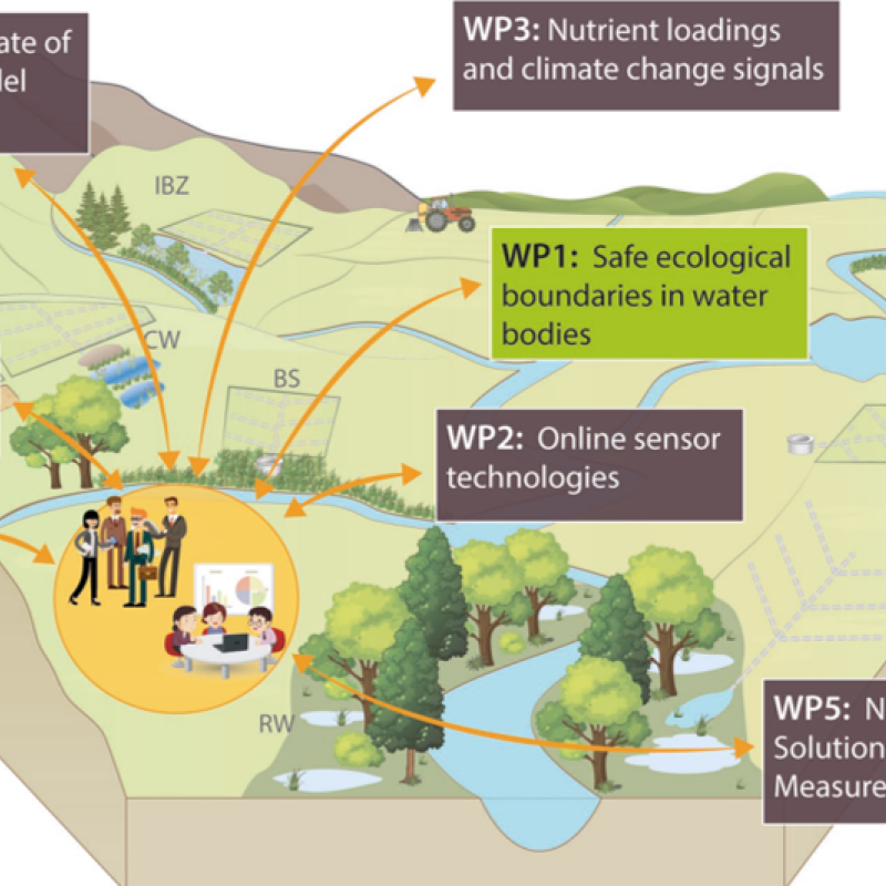
NORDBALT ECOSAFE: Nitrogen and phosphorus load reduction approach within safe ecological boundaries for the Nordic Baltic region

Division of Environment and Natural Resources
OPTAIN: Optimal strategies to retain and re-use water and nutrients in small agricultural catchments
OPTAIN proposes a social and scientific journey toward the increasing and better understanding of the multiple benefits of Natural/Small Water Retention Measures (NSWRM). The Norwegian case study area, Kråkstadelva catchment, is located within the Hobølelva watershed 30 km S-SE of Oslo.

Division of Food Production and Society
Agricultural mitigation measures and the value of water quality improvements
Agriculture is one of the main sources of water pollution in Norway, and an important contributor to GHG emissions.