Robert Barneveld
Research Scientist
(+47) 968 51 427
robert.barneveld@nibio.no
Place
Ås O43
Visiting address
Oluf Thesens vei 43, 1433 Ås
Authors
Trine Eggen Carl Einar Amundsen Robert Barneveld Aksel Bernhoft Barbara Alexandra Bukhvalova Gunnar Sundstøl Eriksen Belinda Flem Christiane Kruse Fæste Tron Øystein Gifstad Merete Grung Veronika Sele Kaja Helvik Skjærven Øystein Sæle Stefan Trapp Christian Vogelsang Håvard SteinshamnAbstract
This report presents a risk assessment of organic contaminants in sewage sludge and sewage-sludge-based products used on agricultural land in Norway, under current and alternative fertiliser regulations and management practices. It identifies a limited number of substances of concern for soil health, aquatic organisms, animal health, and human health, and provides a scientific basis for evaluating circular economy, organic fertilisers, and the safe recycling of bioresources in agriculture. Background and purpose The Norwegian fertiliser regulations was revised in 2025 to support reduced pollution, better utilisation of nutrients, fulfilment of international obligations, simplification, and facilitation of nutrient recycling. In Norway, 50 to 60 per cent of sewage sludge is used on agricultural land, compared with around 40 per cent in the EU. Norway has many small wastewater treatment plants and a long tradition of using treated sludge in agriculture. At the same time, incineration is less common in Norway than in many other European countries, partly because Norwegian wastewater treatment largely relies on chemical phosphorus precipitation (chemical separation of phosphorus). In recent years, new products based on sewage sludge have been developed, such as pellets, biochar and struvite (a fertiliser product recovered from wastewater that makes it possible to recycle phosphorus and nitrogen for agricultural use). At the same time, knowledge about organic contaminants in sewage sludge has increased. On this basis, the Norwegian Food Safety Authority asked VKM to assess the risks associated with organic contaminants in sewage sludge and sludge-based products. Terms of reference and scope VKM was tasked with identifying organic contaminants in sewage sludge and assessing which substances were relevant to include in the risk assessment. The assignment also covered products made from sludge, such as biochar, ash and struvite. Risks were to be assessed for the use of sludge on agricultural land over a period of up to 100 years. If current practice could lead to undesirable effects, alternative application rates and uses were also to be evaluated. In addition, less stringent rules for use in the cultivation of vegetables and on grassland used for mowing and grazing were to be assessed. The assessment covered possible effects on soil-dwelling organisms, aquatic organisms, livestock and humans. Combined effects of multiple substances were not assessed in detail. Methods and scenarios The risk assessment was based on data for more than 1,000 organic contaminants measured in Norwegian sewage sludge. For some pharmaceuticals that had not been analysed, levels were estimated using consumption data and modelling. Substances were prioritised based on occurrence, properties, degradation, mobility and toxicity. A model was developed to calculate how organic contaminants may accumulate and spread in soil, water and plants over time. The calculations were used to assess exposure for soil- and water-dwelling organisms, livestock and humans. The model accounted for climate and soil conditions in five regions in Norway. A wide range of scenarios for the use of sewage sludge and sludge-based products in the cultivation of cereals, potatoes, vegetables and grass were assessed. These included current practice, reduced application rates, use every ten years and annually, different intervals between application and cultivation or grazing, and the use of pellets, biochar, struvite and liquid digestate from sewage sludge. The effects of thermal hydrolysis were also assessed. Summary of main findings Norwegian monitoring data show that municipal sewage sludge contains many different organic contaminants, but levels vary widely between treatment plants and regions. The levels of several legacy pollutants, such as PCBs, PAHs and PBDEs, have decreased over time but are still present in sludge and remain relevant because they degrade slowly and can accumulate in the environment. PFAS are regularly detected, particularly PFOS and other long-chain PFAS. Pharmaceuticals and newer industrial chemicals often occur at low levels but with large variation. Several substances found at the highest concentrations are linked to cosmetics and personal care products. The different sludge-based products have different risk profiles. Pellets are expected to pose roughly the same or slightly lower risk than dewatered sludge. Struvite contains very low levels of organic contaminants and was consistently associated with low risk. Biochar is distinctive in that pyrolysis reduces many organic contaminants, but there is still uncertainty related to the possible formation of new compounds and how residues may be bound or released over time. For soil-dwelling organisms, the assessment showed that current practice may pose a long term risk for some substances. After quality assessment of the data, 19 organic substances showed potential risk, including certain pharmaceuticals, cosmetic-related substances, plastic related compounds, PAHs and PFOS. Lower application rates reduced risk but did not eliminate it. For some persistent substances, annual application could result in a higher cumulative load than application every ten years. For aquatic organisms, under current practice one substance exceeded the risk threshold, the pharmaceutical fenbendazole, but the assessment is uncertain. In scenarios with less stringent conditions or alternative uses, several substances were considered capable of posing a risk to the aquatic environment. For livestock, the calculations generally showed low levels of individual substances in feed rations. Risk was highest for grazing animals, as soil ingestion is an important exposure pathway, and with the use of liquid digestate from sewage sludge, direct intake may also contribute. Delayed grazing after application of products was found to reduce exposure. At the same time, some substances, particularly bisphenols and certain pharmaceuticals, are highlighted as relevant to animal health, and combined effects cannot be ruled out. For humans, current use of sewage sludge is generally assessed to pose relatively low risk to food safety for most of the substances examined. At the same time, an increase in organic contaminants in agricultural soil is undesirable. The report highlights PFAS, PCBs, dioxins, PAHs, PBDEs, siloxanes, bisphenol A, octocrylene and several pharmaceuticals as important for food safety, because dietary exposure to some of these substances is already considered undesirable or of concern. For individuals with high consumption of locally caught freshwater fish, exposure is generally assumed to be limited, but for some individuals it may be relevant. Main conclusion Norwegian data show that sewage sludge contains many organic contaminants, but levels vary widely. Most substances appear to pose low risk to soil-dwelling and aquatic organisms, and low health risk to livestock and humans. Some persistent substances may give rise to concern over time. Struvite was consistently associated with low risk, while pellets, biochar, sewage sludge and liquid digestate from sewage sludge have more complex risk profiles. For humans and livestock, risk is generally low under current practice, but certain groups of substances are undesirable because the overall burden is already high or of concern. The report concludes that some substances should be prioritised for further investigation and follow-up. In summary: VKM concludes that most organic contaminants in sewage sludge pose low risk, but that some organic contaminants may give rise to concern over time. This particularly applies to persistent substances that can accumulate in soil. The report therefore highlights the need for further investigation through the collection of more data and knowledge to support future risk assessments.
Abstract
No abstract has been registered
Abstract
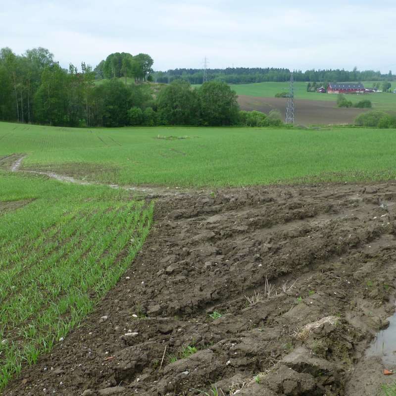
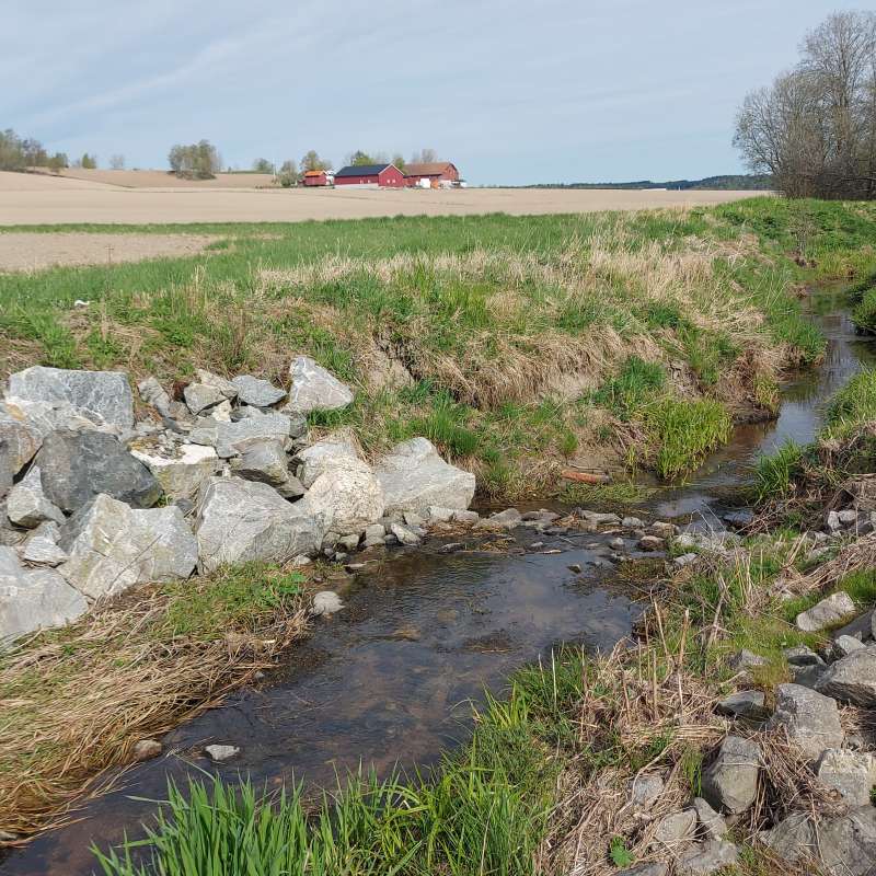
Reducing diffuse nutrient losses to water bodies remains a major problem in the agricultural areas of the Nordic countries. The transition towards a bioeconomy and ongoing climate change raise questions on the future of water quality and freshwater ecosystems and what kind of adaptation strategies could be implemented to maintain both food and environmental safety. The objective of our study was to evaluate the effectiveness of Natural Soil Water Retention Measures (NSWRMs) under current and future climate conditions in retaining water, soil particles and nutrients within the landscape. The hydro-biochemical model SWAT+ was implemented in the Krakstad catchment in southern Norway using the novel approach developed within the EU H2020 project OPTAIN. This approach enables an improved spatial representation of NSWRMs in the landscape. Available discharge and water quality monitoring data were used as reference data for model calibration. The effectiveness of reduced tillage, grassed waterways, sedimentation ponds established in the forested areas and buffers on water retention and nutrient loads was evaluated. Our simulation results indicate that conservation tillage, which maintains stubble on the soil surface during winter, has the strongest impact on reducing soil and nutrient losses towards surface water bodies. Grassed waterways, established in existing erosion prone gullies, could also significantly contribute to water and nutrient retention within the landscape. The implemented NSWRMs did not appear to increase the soil moisture content in early spring even under future climate conditions, which is an important aspect for ensuring soil trafficability and the timing of sowing spring cereals

Division of Environment and Natural Resources
MARCHES - Methodologies for Assessing the Real Costs to Health of Environmental Stressors
Division of Environment and Natural Resources
EUROSION
European Soil Erosion Monitoring and Modelling Network for Sustainable Agricultural Land Management
Division of Environment and Natural Resources
PATH4MED: Demonstrating innovative pathways addressing water and soil pollution in the Mediterranean Agro-Hydro-System.
Path4Med is a multi-participatory and multidisciplinary project that will pave clear pathways towards zero water and soil pollution in the agro-hydro-system of the Mediterranean sea basin and other European seas through an innovative triple bottom line approach achieving economic, social, and environmental sustainability to ensure human well-being and ecosystems functioning.
Division of Food Production and Society
Agricultural mitigation measures and the value of water quality improvements
Agriculture is one of the main sources of water pollution in Norway, and an important contributor to GHG emissions.