Sebastian Eiter

Research Professor

(+47) 974 81 109
sebastian.eiter@nibio.no

Place
Ås O43

Visiting address
Oluf Thesens vei 43, 1433 Ås

Biography

Dr Sebastian Eiter is a geographer and landscape ecologist. His research topics include driving forces and consequences of agricultural landscape change, cultural heritage, biodiversity, public participation and urban agriculture.

Read more
To document

Abstract

This paper provides an overview of traditional hay-making structures and the related agricultural landscapes in Europe. The information was collected using a standardised questionnaire that was completed by experts from different countries. What all countries had in common was that hay production with its corresponding structures was widespread. However, the scope and importance differed among the countries today. We found differences in type and extent, in degree of awareness, and in the cultural meaning of hay-making structures. The differences were connected with built structures, as well as with other tangible and intangible aspects of cultural heritage. The distribution of the broad variety of hay-making-related structures, especially semipermanent ones, has changed throughout history, as well as the hay-making techniques, as a result of agrarian specialisation, land reclamation, and consolidation. Today, in some countries, the relevance of hay-making was mainly connected to horse keeping and landscape management (like in Germany and Hungary), while in others (like Slovakia and Slovenia), it was still predominantly used for cattle and sheep.

To document

Abstract

Over three years, motivations of participants in a neighbourhood garden seemed to reflect the development of the garden from the start-up phase, through consolidation, until a state where further existence requires transitions in responsibility and funding.

To document

Abstract

The objective of this study is to identify the needs related to geospatial LC, LU, and LCLUC information for spatial planning in Poland and Norway, and examine the usefulness of CLMS products in the context of these planning systems. The research has conducted based on a comparative analysis of two planning systems, to indicate areas where CLMS can improve or supplement national spatial data. The study shows that CLMS can provide information on up-to-date spatial data showing actual LC/LU/LCLUC, but that the degree of detail and the accuracy may be insufficient. CLMS data is harmonised across Europe and thus meets the need expressed by international organisations, for data that are consistent at a continental level. This is not a requirement in national planning systems in Poland and Norway, where the needs are regulated by national legislation. The thematic and geometric accuracy of national data sources are usually better than the data provided by CLMS, but CLMS might fill gaps when specific topics are missing in national mapping programs.

To document

Abstract

The Prinzessinnengarten community garden uses Cultural and Culinary Action Days to invite diverse participants to come together to grow food, learn about sustainable urban agriculture and participate in other cultural and culinary activities. The desire to shape one’s own environment is a major motivation for participating, along with a thirst for knowledge and social exchange.

To document

Abstract

The City of Bristol has a long history and well-established practices in urban farming and city food system planning. Farms apply different urban business models that take advantage of the proximity to the city by providing food to city dwellers. Dedicated retailers and restaurants specialize in local food, and a variety of organisations facilitate and promote a resilient and sustainable urban food system.

Abstract

The visual impacts of landscape change are important for how people perceive landscapes and whether they consider changes to be positive or negative. Landscape photographs and photographs of landscape elements may capture information about the visual qualities of landscapes and can also be used to illustrate, and even to quantify, how these visual qualities change over time. We developed a methodology for a monitoring scheme, based on taking photographs from exactly the same locations at different points in time. We tested two methods: one where fieldworkers chose freely the location and direction of photographs, and one where photo locations and four out of five directions were predefined. We found that the method using predefined locations provided a representative sample of the visual qualities present in the landscape and was relatively person-independent but missed rare landscape components. The method using free selection of photo locations and directions captured rarities, but the content of the photos varied from photographer to photographer. Considering the strengths and weaknesses of the two approaches, we recommend a method that combines aspects of both when establishing a monitoring scheme based on repeat photography, with predefined locations to ensure that the entire area is covered, and additional freely chosen photo locations to capture special subject matter that would otherwise be missed.

To document

Abstract

Beetles were surveyed using pitfall traps in a community garden in Andernach, Germany. Two years of data revealed a beetle fauna characteristic of sandy, warm and dry habitats. Sporadic findings include species typical for the Mediterranean.

To document

Abstract

Participating in a neighbourhood and community garden has positive social and emotional impacts, as well as the satisfaction derived from growing food. Adults and teenagers participating in gardening activities at Linderud farm in Oslo report positive experiences most commonly related to social networks, growing food, feelings/emotions and aesthetics.

To document

Abstract

There is widespread agreement that society must urgently go over to renewable energy and that effective participation is crucial for a sustainable transition. Recent literature highlights that the quality of participatory planning is decisive for the acceptance of renewable energy technologies. However, social science research on the issue is dominated by single case studies and the quality of the participatory processes has been rarely studied across wider regional contexts. We present the results of a comparative qualitative inventory of innovative practices from 25 projects in 12 countries in three supra-national European regions. We assessed participation quality according to three analytical dimensions: rationale, inclusiveness, and participation level. An instrumental rationale, broad inclusiveness, and a participation level of consulting or informing was a combination that was commonly perceived as an innovative participatory practice in most regional contexts. We found a tendency towards more advanced practices in Western Europe, compared to Southern, and Eastern Europe. However, practices that were considered to be innovative in the latter regions still provide important lessons within their geographical contexts.

To document

Abstract

From the Middle Ages until the twentieth century, water meadows in Europe were primarily irrigated to improve their productivity and to lengthen the growing season. They were water management systems designed to collect and use water and to discharge it: water had to be kept moving. This chapter presents a general overview and a history of research on European water meadows. It also examines examples from the sandy landscapes of northwestern Europe, from Slovakia, and Norway. Three main types of water meadows are distinguished: simple dam systems, more elaborate catchworks, and highly developed bedworks. Of these, bedworks were technically and organizationally the most complex; they were also the most costly in construction and maintenance. Most water meadows were abandoned in the twentieth century; in many places, however, their traces can still be recognized in the landscape. They are both an interesting part of European agrarian and landscape heritage and a carrier of regional identity. In recent years, a number of water meadows have been restored, for ecological, water management, tourism, and heritage purposes.

Abstract

Norway has a political goal to minimize the loss of cultural heritage due to removal, destruction or decay. On behalf of the national Directorate for Cultural Heritage, we have developed methods to monitor Cultural Heritage Environments. The complementary set of methods includes (1) landscape mapping through interpretation of aerial photographs, including field control of the map data, (2) qualitative and quantitative initial and repeat landscape photography, (3) field recording of cultural heritage objects including preparatory analysis of public statistical data, and (4) recording of stakeholder attitudes, perceptions and opinions. We applied these methods for the first time to the historical clustered farm settlement of Havrå in Hordaland County, West Norway. The methods are documented in a handbook and can be applied as a toolbox, where different monitoring methods or frequency of repeat recording may be selected, dependent on local situations, e.g., on the landscape character of the area in focus.

To document

Abstract

Hay-making structures are part of the agricultural landscape of meadows and pastures. Hay meadows are still used and found all over Europe, but their distribution patterns as well as their characteristics and regional features depend on geographical area, climate, culture, and intensity of agriculture. Intensively used hay meadows are the most dominant, using heavy machinery to store hay mostly as rounded or square bales. Traditional hay-making structures represent structures or constructions, used to quickly dry freshly cut fodder and to protect it from humidity. The ‘ancient’ forms of traditional hay-making structures are becoming a relic, due to mechanisation and the use of new technologies. Both the need for drying hay and the traditional methods for doing so were similar across Europe. Our study of hay-making structures focuses on their current state, their development and history, current use and cultural values in various European countries. Regarding the construction and use of hay-making structures, we have distinguished three different types, which correlate to natural and regional conditions: (1) temporary hay racks of various shapes; (2) hay barracks, a special type of shelters for storing hay and (3) different types of permanent construction and buildings for drying and storing hay. Hay-making structures have been mostly preserved in connection with traditional agricultural landscapes, and particularly in the more remote regions or where associated with strong cultural identity.

To document

Abstract

The COST RELY Glossary on Renewable Energy and Landscape Quality is the result of the European COST RELY project that focused on investigating the influence of renewable energy production on landscape quality. 31 people participated in developing and revising the definitions and descriptions for the 46 terms included in the glossary. Work was done in the period from 2015 to 2017 in multiple rounds of revision done by the RELY experts. Terms in the glossary are clustered into three groups: first group terms are directly connected to the landscape and its characteristics, the second one touches the planning process and methods, and the last one covers different renewable energy sources and production types. Each entry to the glossary consists of six elements: the term, definition, related terms, keywords, illustration(s) and sources. The terms are based on the expert knowledge of the contributors, scientific literature (monographs and articles), EU regulation, relevant web pages and other useful sources, stated in the Reference section. At the end of the glossary, terms are translated into 28 European languages including Esperanto. The glossary targets the researchers from the field, policy makers, local communities, investors in the sector of renewable energy and NGOs concerned with the matter in order to assure that people from different educational background and profession understand and use the term in the same manner. Beside from internal Action use, the terms shall contribute to existing glossaries on the relevant topics.

To document

Abstract

Some previous studies showed that the formation of several deep dark humus-rich topsoils in Northern Europe was strongly influenced by the application of different organic materials by anthropogenic activities in former times. Such topsoils classified as plaggic Anthrosols also occurred in the Jæren region in SW Norway. However, source material and formation time of these Plaggic Anthrosols have not yet been clarified. Close to this region we found further humus-rich topsoils in the Karmøy municipality (2 sites at main island of Karmøy and 1 site at Feøy). These soils show a thick humus-rich topsoil up to 30 cm, and their formation cannot only be explained by natural conditions. We analyzed the molecular signature of the soil organic matter (SOM) by benzene polycarboxylic acids (BPCA), non-targeted bulk SOM mass spectrometry, δ34S and 14C AMS dating in order to determine source materials and the age of the SOM. The black carbon (BC) contents of the plaggic soils in Jæren (mean 3.4 g kg−1) deliver clear evidence for inputs of combustion residues from ancient fire management and/or from settlements. The C-XANES and Py-FIMS-spectra reveal relative enrichments of aromatic C and heterocyclic N compounds in the plaggic soils corresponding to the BC contents. In contrast, the humus-rich topsoils in Karmøy seem to be unaffected by fire management due to the low BC contents (mean 0.6 g kg−1) and the relative low portions of aromatic C and heterocyclic N compounds from C-XANES and Py-FIMS. The δ34S isotope signature of the SOM ranged from 10.6 to 15.2‰ in the soils at the islands and 10.0 to 13.5‰ in Jæren, corresponding to the Anthrosols in the Baltic Sea region (Median: δ34S = 11.5‰) and suggest an input of marine biomass (δ34S of seaweed = 20‰). The AMS 14C dating and complementary archaeological literature implied that the soils in Jæren and Karmøy have been formed between the Roman Iron Age (500 BC to AD 500) and the Viking Age (AD 800 to AD 1,000). Our results provide strong evidence for an anthropo-pedogenesis of the humus-rich topsoils in Karmøy and indicate parallels to the plaggic soils in Jæren as well as to Anthrosols in the Baltic Sea region. Therefore, we propose to classify the humus-rich topsoils in Karmøy as Anthrosols.

Abstract

When ground level photography is to be used in landscape monitoring, it is important to record when, where, how and possibly even why the photographs are taken. Standardisation enables better repeat photography in the future and maximises comparability of photos over time. We used a Cultural Environment protected by law on the peninsula of Bygdøy,Oslo municipality, as a study area to document advantages and disadvantages of different approaches to the first round of landscape photography for long-term monitoring.

To document

Abstract

The successful transition towards renewable energy (RE) technologies is closely intertwined with various societal aspects. Wind energy (WE) is one of the most controversial RE-types, possibly due to the multiplicity of related public concerns. Although some European country-comparisons exist, research concerning acceptance factors in different political and cultural planning contexts is scarce, especially in Eastern and Southern Europe. This paper explores the variation of (1) acceptance issues across Europe, and (2) patterns of strategic and local planning in affecting WE acceptance. We conducted an expert survey among the members of the COST Action ‘Renewable Energy and Landscape Quality’ and the association Wind Energy Europe. We found that acceptance issues – as perceived by the experts – across different regions in Europe share certain similarities, such as concerns about landscape impacts. The priority-levels of acceptance issues are specific to each region and link to the planning quality in that context. Planners’ and decision-makers’ increased awareness about the diversity of acceptance issues would allow them to design more appropriate strategic and local planning processes.

Abstract

No abstract has been registered

To document

Abstract

This article aims to explore differences in motivation for and actual use of allotment gardens. Results from questionnaire surveys and semistructured interviews in two Norwegian and one Dutch garden show that growing vegetables and consuming the harvest is a fundamental part of gardening. The same is true for the social element—meeting and talking to other gardeners, and feeling as part of a community. Although gardeners with different socioeconomic backgrounds experience gardening to some extent similarly, access to an allotment seems more important for gardeners with disadvantaged personal backgrounds: both their diets and their social networks rely more on, and benefit more from, their allotments. This underlines the importance of providing easy access to gardening opportunities for all urban residents, and disadvantaged groups in particular. Public officers and policy makers should consider this when deciding upon new gardening sites or public investments in urban food gardens.

Abstract

Agricultural landscapes are products of farming activity in the past and present. They are everyday landscapes for many people and are important for outdoor recreation. Many plant and animal species find their habitat in these landscapes, and a high number of cultural heritage sites can also be found there. At the same time, agricultural landscapes are continuously subject to change. To ensure sufficient information on how these landscapes change, a national monitoring programme with the acronym “3Q” was initiated in 1998, to document status, continuity and change in agricultural landscapes in Norway. The Division of Survey and Statistics
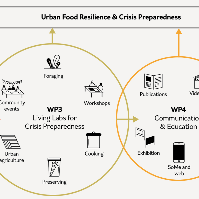
 at NIBIO is responsible for the programme.

To document

Abstract

In the city of Tromsø in northern Norway, invasive Tromsø palm (Norwegian: Tromsøpalme; English: Persian hogweed) is widespread. Although Tromsø palm has negative impacts on biodiversity and contains a phototoxic sap that burns human skin, it is also considered to be a local symbol of Tromsø city and is appreciated by many inhabitants. This study examined private landowners’ characteristics, perceptions, and landowners’ regulation of invasive Tromsø palm on their parcels on Tromsø Island in 2012 (vegetation season: May–September) to provide information concerning which landowner groups could be assisted by official regulation. Eleven key informants and 17 landowners were interviewed. Afterward, Tromsø palm on Tromsø Island was mapped using aerial photos and street-level photos from Google Maps®/Google Street View® and fieldwork verification. This distribution map was superimposed on a property map in a geographic information system to produce a map showing private parcels that contained Tromsø palm and associated neighboring parcels that did not contain Tromsø palm. Questionnaires were mailed to the 441 owners of the selected parcels, and 199 of the returned questionnaires were analyzed. Tromsø palm was more likely to be fully regulated/absent on a parcel that was inhabited (particularly if the owner lived on-site) and less likely to be fully regulated/absent if the parcel was jointly managed by several households. These findings indicate that authorities could focus their management efforts on supporting regulation efforts of those private landowners who own currently uninhabited or rented-out parcels and landowners of parcels jointly managed by several households. Furthermore, those landowners who found regulation measures against the plant on Tromsø Island important tended to have partly or fully regulated Tromsø palm on their plots. This might imply that information campaigns from authorities might encourage more landowners to regulate Tromsø palm.

To document

Abstract

1.To evaluate progress on political biodiversity objectives, biodiversity monitoring provides information on whether intended results are being achieved. Despite scientific proof that monitoring and evaluation increase the (cost) efficiency of policy measures, cost estimates for monitoring schemes are seldom available, hampering their inclusion in policy programme budgets. 2.Empirical data collected from 12 case studies across Europe were used in a power analysis to estimate the number of farms that would need to be sampled per major farm type to detect changes in species richness over time for four taxa (vascular plants, earthworms, spiders and bees). A sampling design was developed to allocate spatially, across Europe, the farms that should be sampled. 3.Cost estimates are provided for nine monitoring scenarios with differing robustness for detecting temporal changes in species numbers. These cost estimates are compared with the Common Agricultural Policy (CAP) budget (2014–2020) to determine the budget allocation required for the proposed farmland biodiversity monitoring. 4.Results show that the bee indicator requires the highest number of farms to be sampled and the vascular plant indicator the lowest. The costs for the nine farmland biodiversity monitoring scenarios corresponded to 0·01%–0·74% of the total CAP budget and to 0·04%–2·48% of the CAP budget specifically allocated to environmental targets. 5.Synthesis and applications. The results of the cost scenarios demonstrate that, based on the taxa and methods used in this study, a Europe-wide farmland biodiversity monitoring scheme would require a modest share of the Common Agricultural Policy budget. The monitoring scenarios are flexible and can be adapted or complemented with alternate data collection options (e.g. at national scale or voluntary efforts), data mobilization, data integration or modelling efforts.

To document

Abstract

Accessibility is a central issue for human activity, particularly in mountain areas. We investigate changes in physical accessibility in a Western Norwegian mountain area during the past 40–60 years and identify driving forces of changes. Changes in accessibility were measured as changes in travel time between permanently and seasonally inhabited farmsteads. Additionally, travel time from new access points in the mountains was calculated. C.75% of the investigated access routes to seasonal farmsteads have remained unchanged due to continued use or maintenance work, or been slightly improved due to development of paths into roads. In addition, new access routes have emerged as a result of road construction. Regrowth of paths due to abandonment of seasonal farming has reduced accessibility. Changes in accessibility have led to a concentration of activities in more easily accessibly parts of the study area. Documented changes in accessibility result from a complex interaction of driving forces that initiate or influence change. Important drivers interacting with road construction and abandonment of seasonal farming can be categorized as socio-economic, political and technological. However, the importance of culturally rooted commitment of local people or a small number of enthusiasts must not be underestimated.

Abstract

This report is a means to help establishing a common foundation through providing a brief summary of different themes of importance for scientists involved in the research project “Space, land and society: challenges and opportunities for production and innovation in agriculture based value chains” (AGRISPACE) funded by the Research Council of Norway. The overarching objective of AGRISPACE is to provide comprehensive knowledge on challenges and opportunities for sustainable growth in production and innovation in land-based bio-production across space.

To document

Abstract

Public participation in landscape planning and management has received increased attention acrossEurope since the European Landscape Convention (ELC) came into force in 2004. The ELC has now beenratified by many countries, which have been working on its implementation for up to several years. In thisarticle, we study experiences from public participation in five different planning processes in Norway,and we assess the methods used according to a set of evaluation criteria developed in a European context:Scope, Representativeness, Timing, Comfort and Convenience, and Influence. Subsequently we identifyten singular methods as being particularly effective in terms of contributing significantly to increasingscores of Scope, Representativeness, and Comfort and convenience, i.e. the criteria most influenced by themethods chosen. All ten methods identified contribute to increase scores on one or two evaluation crite-ria, which underlines the importance of combining different methods to achieve effective participationwithin the restricted framework of a concrete spatial planning process. In an international perspectiveit seems most fruitful to apply a set of both dominantly verbal methods as practiced in Norway andsomewhat more visual approaches used in other countries. This would also acknowledge basic differ-ences among theoretical understandings of landscape and follow a recent scientific development of theconcept of landscape.

Abstract

This review identifies ‘successful’ policies for biodiversity, cultural heritage, and landscape scenery and recreation in Austria, France, Bavaria (Germany), Wales (UK), and Switzerland, and a comparison with current efforts in Norway. All of these countries face similar risks and challenges, mostly with regard to mountain areas. Sources used for the analysis were the evaluations of the national Rural Development Plans, and the midway evaluation and national ex-post evaluations of the CAP programme period 2000–2006. An evaluation of the Swiss Direct Payment System was available from 2009, as well as information about further development from 2011. Scientific papers and other official reports by, e.g., the OECD, the European Commission and the European Environmental Agency, were used as well. Expert interviews were conducted by telephone and e-mail. Measures deemed particularly successful often had very specific aims, included local information, appeared to involve fairly simple application and organization requirements, were developed and designed in cooperation with farmers and were adapted to local characteristics or challenges. Measures considered less successful were criticized for being unfair in terms of regional repartition of grants, for lacking transparency, for being applied only to small areas, and for requiring a great deal of organization and implementation work. In terms of future developments of the Norwegian agricultural and agri-environmental subsidy system we recommend examining the following particular policies more closely: the Organic Farming scheme in Austria, the Welsh whole-farm scheme Tir Gofal, and the Austrian, Bavarian and Swiss measures for cultural landscape maintenance. Since no ‘best practice’ or ‘standard design’ of agricultural support schemes has been recognized on an international level to date, an enhanced evaluation system will be as important as new and adjusted schemes. Monitoring data suitable for comparison should be collected, based on internationally defined indicators. For the time being, we suggest “double-tracked” agri-environmental support: mainly measures that have proved to be effective; but also measures where positive effects are considered very likely due to well-known cause-effect relationships, even though they may not yet have been thoroughly documented and approved, e.g. because of their long-term character or due to weaknesses in monitoring and evaluation.

To document

Abstract

No abstract has been registered

Abstract

No abstract has been registered

Abstract

No abstract has been registered

Abstract

No abstract has been registered

Abstract

No abstract has been registered

To document

Abstract

The involvement of the public in decision-making is established as a key feature of many planning policies. However, there is evidence from the literature of a prevailing gap between participation rhetoric on paper and participation at the operational level. We assess whether this is also the case with landscape policy and review landscape characterization and assessment initiatives in England, Norway, Slovakia and Malta, focusing on five dimensions of good practice: (i) scope of public participation, (ii) representativeness of those involved, (iii) timeliness of public involvement, (iv) extent to which participation is rendered comfortable and convenient for the public, and (v) eventual influence of public input on decisions. Reviewed reporting results indicate weaknesses in the implementation of public participation, with public involvement largely limited to consultation, with few efforts to ensure representativeness of participants, with predominantly late involvement of the public, and with limited influence of the public on outputs. Furthermore, few efforts appear to be made to facilitate participation for the public. Although the cases studied differ, none of them are fully satisfactory in relation to the European Landscape Convention's participatory targets. The reporting of public participation processes thus suggests that practices may fail to match the rhetoric.

Abstract

This article uses an activity-based understanding of landscape to explore values related to perceived land cover diversity. Perceptions within two user groups, members of landowner families and hiking tourists in a mountain area in western Norway, were related to a simultaneous land cover survey, and compared to experts' evaluations of land cover and to the aims of landscape protection in the area. Users perceived the area as being significantly more diverse and valuable than experts did, which stresses the importance of taking user perception into account in landscape protection and management. Some central landscape values were dependent upon land use outside the boundaries of the protected area. This illustrates that measures within structurally defined land units are not necessarily sufficient for maintenance of landscape values experienced by users. Land use in both respects, as an upholder of values and as a way of experiencing or perceiving them, should receive an increased role in the determination of management units.