Stefano Puliti
Research Scientist
Authors
Xinlian Liang Yinrui Wang Jun Pan Janne Heiskanen Ningning Wang Siyu Wu Ilja Vuorinne Jiaojiao Tian Jonas Troles Myriam Cloutier Stefano Puliti Aishwarya Chandrasekaran James Ball Xiangcheng Mi Guochun Shen Kun Song Guofan Shao Rasmus Astrup Yunsheng Wang Petri Pellikka Mi Wang Jianya GongAbstract
No abstract has been registered
Authors
Stefano Puliti Binbin Xiang Maciej Wielgosz Eivind Handegard Nicolas Cattaneo Marta Vergarechea Terje Gobakken Juha Hyyppä Erik Næsset Mikko Vastaranta Tuomas Yrttimaa Rasmus AstrupAbstract
Accurately determining the age of individual trees is important for understanding forest dynamics, tree growth, site productivity and describing ecological processes. Traditional methods, such as dendrochronological coring, are invasive, labor-intensive, and costly. This study investigates the use of deep learning (DL) to predict tree age from high-density laser scanning data as a scalable, non-invasive alternative. The dataset includes approximately 1700 tree point clouds from approx. 1 K trees across Norway, Sweden, and Finland, encompassing Norway spruce (Picea abies) and Scots pine (Pinus sylvestris) and a broad range of tree age and developmental stages, from young seedlings (1 year) to old trees (∼350 years). Data were collected using terrestrial, mobile, and high-density airborne laser scanning platforms, enabling the development of sensor-agnostic models. We evaluated multiple modelling approaches, from linear regression to transformer architectures, using both training-from-scratch and fine-tuning strategies. Models fine-tuned starting from pre-trained weights from ForestFormer3D's U-Net as well as the transformer architecture (PointTransformerV3) trained from scratch, proved effective for age regression (RMSE ≤23 years). Although our analysis was limited to two tree species, we demonstrated that a single joint age-estimation model can be successfully trained for both species. We demonstrate that models trained on high-resolution data can generalize to lower-resolution, less costly inputs, provided that data augmentations that mimic reduced resolutions are included during training. This study presents a data-driven framework for estimating tree age without destructive sampling. The findings support the potential for AI-based methods to complement or replace traditional age estimation techniques in forest inventory and monitoring.
Authors
L. Duncanson P. M. Montesano A. Neuenschwander A. Zarringhalam N. Thomas D. M. Minor M. A. Wulder J. C. White E. Guenther T. Feng V. Leitold S. Hancock J. Armston Stefano Puliti A. I. Mandel S. Shah C. Silva M. Purslow J. Bruening Johannes Breidenbach Erik Næsset Svetlana Saarela N. Hunka J. R. Kellner S. P. Healey D. Schepaschenko J. Wallerman C. S.R. Neigh N. Carvalhais R. DubayahAbstract
No abstract has been registered
Division of Forest and Forest Resources
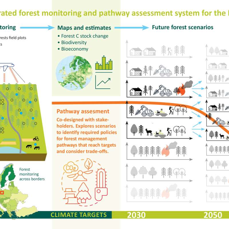
PathFinder - Towards an Integrated Consistent European LULUCF Monitoring and Policy Pathway Assessment Framework
Division of Forest and Forest Resources
A Decision Support System for emerging forest management alternatives
This project aims to develop advanced tree growth models using LiDAR-derived, high-density point cloud data to improve the simulation of forest dynamics under close-to-nature silvicultural practices. By modeling tree-level growth in structurally complex and heterogeneous stands, these models will support more accurate, spatially explicit forest simulations and inform sustainable and diversified forest management decisions.
Division of Forest and Forest Resources
SFI SmartForest: Bringing Industry 4.0 to the Norwegian forest sector
SmartForest will position the Norwegian forest sector at the forefront of digitalization resulting in large efficiency gains in the forest sector, increased production, reduced environmental impacts, and significant climate benefits. SmartForest will result in a series of innovations and be the catalyst for an internationally competitive forest-tech sector in Norway. The fundamental components for achieving this are in place; a unified and committed forest sector, a leading R&D environment, and a series of progressive data and technology companies.